DrainsofmyCity
The Spiral Drain, a Unique Engineering Feat
2014
Above the cliffs there is a nondescript, round tower. Roughly four feet high, it is faced with grey landscaping blocks, and sits in a low grassy area. As you approach, the sound of rushing water can be heard. Climb onto the flat concrete top of the little tower. There is a large grate in the center, and humid wind rushes up through the metal bars. Peer into the black hole and you'll see jets of water whirling down the shaft walls into darkness.

Looking down into the 200 foot high vortex shaft.
One of a kind in Canada, second on the continent
Since moving to Vancouver years ago I'd heard about this one-of-a-kind vortex, but like most people my investigation of the mysterious structure was limited to looking into its depths from the surface. But what is this ominous vortex? Why is it here? And what else is beneath the surface?
My curiosity eventually drew me out of the house on a cold, clear night, prepared with the usual exploring gear: rubber boots, several flashlights, and a camera. I'd come to find out what secrets lay below.
A donut-shaped room with stained white walls and wisps of fog hanging in the air. Murky water lapped into the central column through a grid of thick metal bars. I cautiously dipped a foot, and when I touched bottom the water was luckily just below the top of my boot. I slowly crept into the chamber, but the ceiling was only about five feet high, so I still couldn't stand up straight. 90 degrees around the donut, another pipe came out of the wall, and as I walked over to examine it water began to lap into my boots. Determined to look around, I quickly resigned myself to wet feet. Several pipes dumped into the donut-room, but all were about the same 30" high. Peering into the pipes with a flashlight did not reveal anything that seemed worth the effort of crouch-walking their concrete lengths.
The "donut hole" had four equally spaced chambers guarded by thick rusty bars. Fed by falling water, each of these pits had a small nozzle exit into the unseen 200 foot drop-shaft in the centre. The humid air made it difficult to get clear photographs of anything.
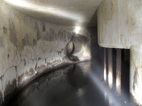
Four trunk sewers connect into the circular receiving tank.
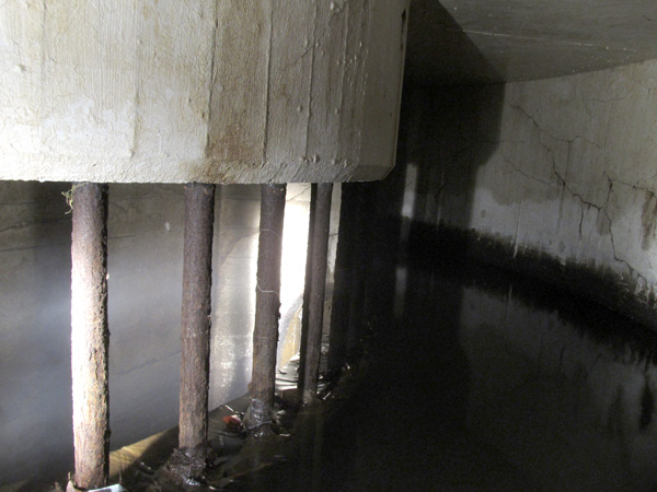
Water flows past these metal bars, over the edge into one of four central wells.
There were two manhole shafts into the room, which were the only spots where I could stand upright to give my back muscles a rest.
It didn't take long for my water-logged toes and cramped back muscles to encourage my exit. My exit was quick and dirty, the manhole cover kicked easily back into its seat. I sat on frosty grass and wrung smelly water from my socks, my pants soaked from the knees down but warm and steaming in the cold night air.
Although I didn't explore beyond the spiral chamber, leaving the collection trunk pipes unknown, my curiosity was satisfied for the night. The bottom of the shaft and the outfall tunnel are inaccessible, but I hoped some research at the archives would provide answers.
The Washout of 1935
The "Grand Campus Washout" occurred at the end January 1935. Frosty conditions, a high snowfall, and record-breaking precipitation overwhelmed the drainage ditches at the north end of the campus. Jordan Creek became a river that quickly eroded the soft, sandy ground near the cliffs. The ravine banks collapsed, taking down a bridge, many trees, and washed a huge plume of sand down to the ocean. Roads were closed, sewer lines were severed, buildings perched perilously close to the newly enlarged gully, and something had to be done.
To avoid another disastrous washout, the Provincial Government (responsible for the University Endowment Lands at the time) contracted the Vancouver & Joint District Sewerage & Drainage Board to solve the problem. After examining the options, the V&JDS&DB designed a system of collection sewers and ditches to collect runoff, and a shaft to drop the water straight down to an outfall tunnel which would carry the water safely away. Modeled on the design of an existing drainage shaft in Boston, Mass., the shaft would be lined with helical threads to dissipate the energy of the falling water.
Construction of the spiral drain shaft and outfall tunnel began midway through 1935, and were the key structures of a larger project to lay new sewers and fix washout damage. At first the shaft was dug quickly, a rate of 14 feet a day, but 146 feet down a layer of quicksand was reached and the shaft had to be continued under an air lock. During excavation a piece of fossilized wood was discovered and later identified as being from a spruce tree that lived 100,000 years ago.
The bottom of the shaft and outfall tunnel were driven in a layer of fine, dry sand which "ran like cornmeal", necessitating tight sheeting of the walls. The ground conditions caused some delay and extra cost but the tunneling work was completed satisfactorily, after which a foot of concrete was poured in between wooden forms and the outer liner plates. The helical grooves in the 4 foot diameter shaft were created using a special wooden form built by the Canadian Wood Pipe and Tank Co.
The works were completed on May 12th, 1936; final cost of the outfall and tunnel $16,160, the shaft and receiving chamber $39,655.
The north catchment area of the UBC campus is presently drained by four trunk sewers, each about 30 inches in diameter, that feed into the receiving tank of the spiral drain. This tank, shaped like a donut, is approximately 20 feet across with an 8 foot diameter center column that has four grated openings for water to fall through. The water goes into the chambers in the column and is directed tangentially into the shaft. After swirling all the way to the bottom, there is a "water cushion" to absorb energy, and the water is discharged down the outfall tunnel.
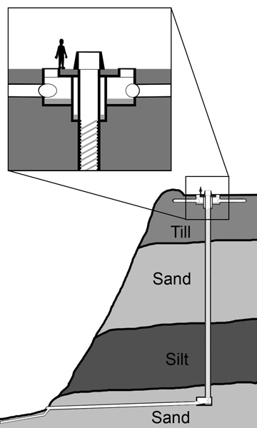
Diagram indicating general arrangement of trunk sewers, receiving tank, spiral shaft, water cushion chamber, outfall tunnel, and geology of Point Grey cliffs.
Further improvements to the drainage structures have been carried out since initial construction. Rock fill was dumped to build up the beaches to slow erosion on the lower cliffs. The original outfall discharged above the high tide mark but caused a fair amount of erosion and required additional shoring. Eventually a pipe was laid under the beach, diverting the stormwater out into the ocean, and the old outfall was permanently sealed.
After some minor flood erosion in 1994, earth berms were constructed above the cliff edge to contain surface water and grates installed in a nearby roadway. The shaft has been capped with a vent tower to raise the grate opening above flood level.
Erosion of the sand banks underlying the north end of campus continues to be a significant issue, and poses a threat to nearby historic buildings like Cecil Green House. The University has commissioned many studies of the problem, and stormwater management continues to be a priority as the campus develops. Almost 80 years after its construction the unique spiral drain continues to be the key structure that prevents another disastrous campus washout.
Further Reading:
The Grand Campus Washout, by Dr. M. Y. Williams, Prof. Em.
UBC Alumni Chronicle, Volume 20, No. 4, Winter 1966
http://www.library.ubc.ca/archives/pdfs/chronicle/AL_CHRON_1966_4.pdf
UBC Will seek public reaction to erosion plan
UBC Reports, Vol 26 No. 16, Sept 12, 1979
http://www.library.ubc.ca/archives/pdfs/ubcreports/UBC_Reports_1979_09_12.pdf#search=%22spiral%20drain%22